The objective of this lab was to create an online survey in ArcGIS online using the Survey123 lesson. The results from the survey could then be brought into the Survey123 Field App and an interactive map was created displaying the results of the survey.
Methods
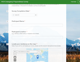
The first step for this lab was to create a survey using the Survey123 website. The survey created was HOA Emergency Preparedness Survey. The survey consisted of 29 questions that were to designed to gauge a community's preparedness for an natural disaster. These questions consisted of questions such as surveyors name, location, housing information, and levels of preparedness (fig. 1). The questions were added using the add function. This function allowed for a variety of different types of questions to be added such as multiple choice, single choice (yes or no), and location maps.
 |
| Figure 1. An example of the questions used to complete the survey. |
After the new survey results were sent from the Survey123 app, the next step of the lab was to analyse the results and create an interactive map displaying the results under the Analyze tab. This tab allows for the results of each individual question (fig. 2) and the location for each of the survey responses (fig. 3).
 |
| Figure 2. |
 |
| Figure 3. |
 |
| Figure 4. |
The Survery123 allows for surveys to be created and shared with the public. The data can be easily analyzed and the locations of the respondent can be used to analyze spatial spatial patterns survey. This information can then be brought into an app where members of the same organization can have easy access to the survey information.
Sources
Learn ArcGIS: Lessons: Get Started with Survey123 ArcGIS
https://learn.arcgis.com/en/projects/get-started-with-survey123/lessons/create-a-survey.htm

No comments:
Post a Comment